


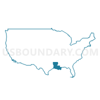
Precinct 560, Calcasieu Parish, Louisiana
About
Outline

Summary
| Unique Area Identifier | 588317 |
| Name | Precinct 560 |
| County | Calcasieu Parish |
| State | Louisiana |
| Area (square miles) | 86.51 |
| Land Area (square miles) | 86.42 |
| Water Area (square miles) | 0.10 |
| % of Land Area | 99.89 |
| % of Water Area | 0.11 |
| Latitude of the Internal Point | 30.35450420 |
| Longtitude of the Internal Point | -93.64965460 |
Maps


Graphs
Select a template below for downloading or customizing gragh for Precinct 560, Calcasieu Parish, Louisiana


Neighbors
Neighoring Voting District (by Name) Neighboring Voting District on the Map
- Voting District 0010, Newton County, TX
- Voting District 0011, Newton County, TX
- Precinct 1, Beauregard Parish, LA
- Precinct 561, Calcasieu Parish, LA
- Precinct 562, Calcasieu Parish, LA
- Precinct 661, Calcasieu Parish, LA
Top 10 Neighboring County Subdivision (by Population) Neighboring County Subdivision on the Map
- District 11, Calcasieu Parish, LA (12,625)
- District 1, Beauregard Parish, LA (3,724)
- Deweyville CCD, Newton County, TX (3,455)
- Call CCD, Newton County, TX (2,690)
Top 10 Neighboring Place (by Population) Neighboring Place on the Map
Top 10 Neighboring Unified School District (by Population) Neighboring Unified School District on the Map
- Calcasieu Parish School District, LA (192,768)
- Beauregard Parish School District, LA (35,654)
- Deweyville Independent School District, TX (3,701)
Top 10 Neighboring State Legislative District Lower Chamber (by Population) Neighboring State Legislative District Lower Chamber on the Map
Top 10 Neighboring State Legislative District Upper Chamber (by Population) Neighboring State Legislative District Upper Chamber on the Map
Top 10 Neighboring 111th Congressional District (by Population) Neighboring 111th Congressional District on the Map
- Congressional District 8, TX (833,770)
- Congressional District 7, LA (676,785)
- Congressional District 4, LA (667,109)
Top 10 Neighboring Census Tract (by Population) Neighboring Census Tract on the Map
- Census Tract 36, Calcasieu Parish, LA (4,175)
- Census Tract 9504, Newton County, TX (3,455)
- Census Tract 9606, Beauregard Parish, LA (3,257)
- Census Tract 23, Calcasieu Parish, LA (2,835)
- Census Tract 9503, Newton County, TX (2,690)
Top 10 Neighboring 5-Digit ZIP Code Tabulation Area (by Population) Neighboring 5-Digit ZIP Code Tabulation Area on the Map
- 77632, TX (22,776)
- 77612, TX (8,901)
- 70633, LA (7,604)
- 70668, LA (6,424)
- 70660, LA (2,612)
- 70661, LA (2,309)
- 77614, TX (603)